Object Number 41-72-10/110
Display Title 
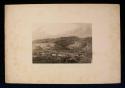
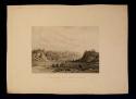
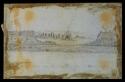
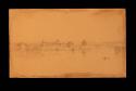
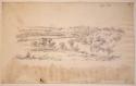
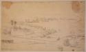
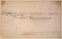
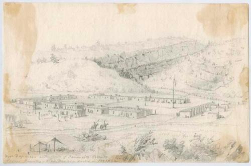
"Fort Defiance, at the mouth of the Canoncito Benito, Navajo County, New Mexico"
Descriptions
Object Description "Fort Defiance, at the mouth of the Canoncito Benito, Navajo County, New Mexico, erected in 1851-1852." Pencil sketch.
Classification
  • Drawing
Date 19th century
Artist Seth Eastman
Geography/Provenience/Site Name
North America / United States / New Mexico
Dimensions Overall: 16.5 x 23.6 cm (6 1/2 x 9 5/16 in.)
Label on object Descriptive title, in pencil

Important Note about Historical Language

Collections records may contain language, reflecting past collecting practices and methods of analysis, that is no longer acceptable. The Peabody Museum is committed to addressing the problem of offensive and discriminatory language present in its database. Our museum staff are continually updating these records, adding to and improving content. We welcome your feedback and any questions or concerns you may want to share. Please email us with your comments.

PrimaryMedia Object Number Title Classification Geography/Provenience SHARE
"Fort Defiance at Canoncito Bonito, New Mexico"
41-72-10/135 "Fort Defiance at Canoncito Bonito, New Mexico"
Print
New Mexico
Fort Defiance, at the mouth of the Canoncito Benito
2004.24.21655 Fort Defiance, at the mouth of the Canoncito Benito
Fort Defiance
"Near Fort Defiance, Navajo Country, New Mexico"
41-72-10/138 "Near Fort Defiance, Navajo Country, New Mexico"
Print
New Mexico
"Fort Defiance."
41-72-10/546 "Fort Defiance."
Drawing
North America
"View Near Fort Defiance (Pedroyal)"
41-72-10/548 "View Near Fort Defiance (Pedroyal)"
Drawing
North America
Fort Defience at Canoncito Benito, New Mexico; Engraved by S. Eastman
2004.24.21658 Fort Defience at Canoncito Benito, New Mexico; Engraved by S. Eastman
Fort Defiance
Fort Defiance
2004.24.31055 Fort Defiance
Navajo County
"Fort Armstrong, on Rock Island from Davenport"
41-72-10/195 "Fort Armstrong, on Rock Island from Davenport"
Drawing
Fort Armstrong
"Mississippi River-Fort Armstrong, Rock Island, 357 miles Above St.Louis"
41-72-10/103 "Mississippi River-Fort Armstrong, Rock Island, 357 miles Above St.Louis"
Drawing
North America
"View from Tower on Fort Snelling looking northwest"
41-72-10/155 "View from Tower on Fort Snelling looking northwest"
Drawing
North America
"Drawing of the St. Peters from Fort Snelling"
41-72-10/152 "Drawing of the St. Peters from Fort Snelling"
Drawing
North America
"View of the Tower of Fort Snelling, looking east"
41-72-10/153 "View of the Tower of Fort Snelling, looking east"
Drawing
North America