Object Number 2004.24.12971
Display Title 
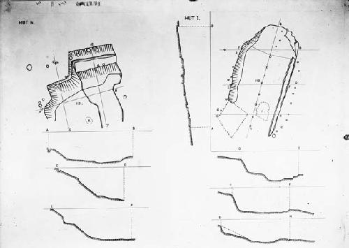
Plan drawings of huts g and i
Descriptions
Object Description 
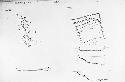
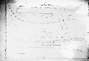
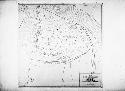
Plan drawings - Huts G and I. Czechoslovakia: Bohemia, Stehelceves - Homolka. Hut "I" - to right is indicated by movies in Jo Braton's reel. She also has a photo of "G" just after the palisade and gate #2.
Subject
  • Hut
  • Drawing
  • Plan
  • Schematic
  • Architecture
Department Photographic
Date 1931
Artist Central European Expedition
Culture
  • Aeneolithic
  • Nordic
Geography/Provenience/Site Name
Europe / Czech Republic / Bohemia / <County> / Stehelceves / Homolka
Intrasite Hut G, I
Additional Geographic Terms Kladno
Dimensions Overall: 12.7 x 17.78 cm (5 x 7 in.)

Important Note about Historical Language

Collections records may contain language, reflecting past collecting practices and methods of analysis, that is no longer acceptable. The Peabody Museum is committed to addressing the problem of offensive and discriminatory language present in its database. Our museum staff are continually updating these records, adding to and improving content. We welcome your feedback and any questions or concerns you may want to share. Please email us with your comments.

PrimaryMedia Object Number Title Classification Geography/Provenience SHARE
Plan drawings of Huts H and M
2004.24.12970 Plan drawings of Huts H and M
Homolka
Vase and Jug top from excavation
2004.24.12984 Vase and Jug top from excavation
Homolka
Image Not Available for Plan of the late Neolithic Fort, Homolka, Stehelceves - Bohemia
65-41-40/336.3 Plan of the late Neolithic Fort, Homolka, Stehelceves - Bohemia
Homolka
Image Not Available for Plan of the late Neolithic Fort, Homolka, Stehelceves - Bohemia
65-41-40/335 Plan of the late Neolithic Fort, Homolka, Stehelceves - Bohemia
Homolka
Image Not Available for Plan of the late Neolithic Fort, Homolka, Stehelceves - Bohemia
65-41-40/335.1 Plan of the late Neolithic Fort, Homolka, Stehelceves - Bohemia
Homolka
Image Not Available for Plan of the late Neolithic Fort, Homolka, Stehelceves - Bohemia
65-41-40/336.2 Plan of the late Neolithic Fort, Homolka, Stehelceves - Bohemia
Homolka
Image Not Available for Plan of the late Neolithic Fort, Homolka, Stehelceves - Bohemia
65-41-40/336.1 Plan of the late Neolithic Fort, Homolka, Stehelceves - Bohemia
Homolka
Schematic chart of palisade details with sections, south slope of Homolka
2004.24.12969 Schematic chart of palisade details with sections, south slope of Homolka
Homolka
Master plan of Homolka after completion of excavation
2004.24.12972 Master plan of Homolka after completion of excavation
Homolka
Image Not Available for Field notes, maps, plans, excavations at U Cihelny and V Rovinach, Stehelceves, Bohemia (Czechoslovakia)
34-45-00/1 Field notes, maps, plans, excavations at U Cihelny and V Rovinach, Stehelceves, Bohemia (Czechoslovakia)
Stehelceves
Copy of drawing showing possible reconstruction of pot
2004.24.14396 Copy of drawing showing possible reconstruction of pot
Homolka
Stehelceves Laboratory - engineers, etc
2004.24.12851 Stehelceves Laboratory - engineers, etc
Homolka