Skip to main content
Object Number
65-41-10/256.20
Display Title
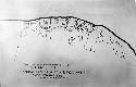
Map of Chinle Caynon at Kin Na Ilth
Descriptions
Department
Archival, Oversize Paper
Geography/Provenience/Site Name
North America
/
United States
/
Arizona
/
Apache County
Important Note about Historical Language
Collections records may contain language, reflecting past collecting practices and methods of analysis, that is no longer acceptable. The Peabody Museum is committed to addressing the problem of offensive and discriminatory language present in its database. Our museum staff are continually updating these records, adding to and improving content. We welcome your feedback and any questions or concerns you may want to share. Please email us with your comments.