Skip to main content
Object Number
2010.1.29.36
Display Title
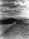
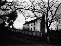
Water worn rock (glacial deposit) on the road (about 1/8 mile from the bluff) to the Lalor homestead
Descriptions
Object Description
Water worn rock (glacial deposit) on the road (about 1/8 mile from the bluff) to the Lalor homestead and near the trences explored April and May, also June, 1897. Plate 3
Department
Photographic
Geography/Provenience/Site Name
North America
/
United States
/
New Jersey
/
Mercer County
/
Trenton
/
Abbott Farm Complex
/
Lalor Farm
Intrasite
1/8 mile from bluff
Materials
glass plate
Dimensions
Overall: 12.7 x 17.78 cm (5 x 7 in.)
Quantity
1
Important Note about Historical Language
Collections records may contain language, reflecting past collecting practices and methods of analysis, that is no longer acceptable. The Peabody Museum is committed to addressing the problem of offensive and discriminatory language present in its database. Our museum staff are continually updating these records, adding to and improving content. We welcome your feedback and any questions or concerns you may want to share. Please email us with your comments.