Skip to main content
Object Number
86-46-00/2.1
Display Title
Diagram Turpin Mound
Descriptions
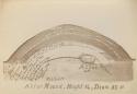
Object Description
Diagram of Turpin Ancient Cemetery & vicinity, Anderson Township, Hamilton County, Ohio. Survey No. 416. Scale of 50 ft to 1 in. June 25th 1885.
Department
Archival, Oversize Paper
Date
June 25 1885
Geography/Provenience/Site Name
North America
/
United States
/
Ohio
/
Hamilton County
/
Anderson Township
/
Turpin Archaeological District
Materials
Ink on Paper
Dimensions
Overall: 49.5301 × 63.5001 cm (19 1/2 × 25 in.)
Quantity
1
Important Note about Historical Language
Collections records may contain language, reflecting past collecting practices and methods of analysis, that is no longer acceptable. The Peabody Museum is committed to addressing the problem of offensive and discriminatory language present in its database. Our museum staff are continually updating these records, adding to and improving content. We welcome your feedback and any questions or concerns you may want to share. Please email us with your comments.