Skip to main content
Object Number
2004.15.7.32
Display Title
Topographic Map of Xcalumkin
Descriptions
Object Description
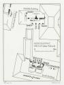
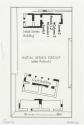
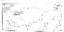
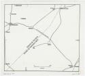
Xcalumkin / Contours from 1:50,000 map
Department
Archival, Oversize Paper
Artist
Ian Graham
Culture
- Maya area styles and periods
Geography/Provenience/Site Name
Central America
/
Mexico
/
Campeche
/
<County>
/
Holactun
/
Xcalumkin
Materials
Commercial print on Paper vellum
Dimensions
Overall: 73 × 27 cm (28 3/4 × 10 5/8 in.)
Important Note about Historical Language
Collections records may contain language, reflecting past collecting practices and methods of analysis, that is no longer acceptable. The Peabody Museum is committed to addressing the problem of offensive and discriminatory language present in its database. Our museum staff are continually updating these records, adding to and improving content. We welcome your feedback and any questions or concerns you may want to share. Please email us with your comments.