Object Number 10-61-00/2.9
Display Title 
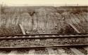
Stratification of sand and clay deposits, looking southwest
Descriptions
Object Description Written on photograph (verso): "No 1 Aug. 31st 1910. / Exploration in the Delaware Valley / under the direction of Prof. F.W. / Putnam for Peabody Museum of / Archaeology & Ethnology Cambridge / Mass. by Ernest Volk. / View looking S.W. showing stratification of sand / and clay reaching up to the surface in a / regular arch. This is reaching for a distance / of 200 feet when to the NE peculiar heavy clay / deposits (irregular) are shown up with / several ice pits."
Department Photographic
Date August 31, 1910
Artist Ernest W. Volk
Culture
  • Pre-Columbian Eastern North American styles
Geography/Provenience/Site Name
North America / United States / New Jersey
Additional Geographic Terms Delaware Valley
Dimensions Overall: 12.7 × 17.78 cm (5 × 7 in.)
Quantity 1
Credit Line Peabody Museum Expedition, F. W. Putnam, Director, 1910

Important Note about Historical Language

Collections records may contain language, reflecting past collecting practices and methods of analysis, that is no longer acceptable. The Peabody Museum is committed to addressing the problem of offensive and discriminatory language present in its database. Our museum staff are continually updating these records, adding to and improving content. We welcome your feedback and any questions or concerns you may want to share. Please email us with your comments.

PrimaryMedia Object Number Title Classification Geography/Provenience SHARE
Media Restricted
2004.29.1182 Showing Heavy deposits of a brownish yellow clay, twisted into a horseshoe shape
Trenton
Boulder line Columbian deposits near Darley's hodge, carpenter station, B and O
2004.29.691.10 Boulder line Columbian deposits near Darley's hodge, carpenter station, B and O
Delaware
Image Not Available for Figure 5 - Sections of Pits Dug in the Early Post-Glacial Deposits between the W
2005.2.346.3 Figure 5 - Sections of Pits Dug in the Early Post-Glacial Deposits between the W
Ireland
Media Restricted
10-61-00/2.6 Highest point of terrace west of Lalor Farm, looking southwest
Lalor Farm
Media Restricted
10-61-00/2.10 Wall of sand pit
New Jersey
Media Restricted
2004.29.1234 Looking North showing clay deposits & pits with large boulders.
Trenton
Test pit 102 with stratification of river deposits
58-34-20/59465 Test pit 102 with stratification of river deposits
Jonuta
Image Not Available for Figure 3, sections of pits dug in the glacial terrace, showing the deposits.
2005.2.346.1 Figure 3, sections of pits dug in the glacial terrace, showing the deposits.
Ireland
Image Not Available for Specimens of salt deposits
40-53-60/8422 Specimens of salt deposits
Mineral
Miran
Section A Deposits E &G. See chart. Burial place.
2004.29.902 Section A Deposits E &G. See chart. Burial place.
Bucksport
Section A deposits B and D and plummet 15 see chart of burial place.
2004.29.903 Section A deposits B and D and plummet 15 see chart of burial place.
Bucksport
Image Not Available for 11 potsherds (Vasquez Complex sherds founds in Barklog Complex deposits) - type
62-31-20/22554 11 potsherds (Vasquez Complex sherds founds in Barklog Complex deposits) - type
Sherd
San Estevan